![]()
![]()
![]()

Netatmo GeoPy
Pythonic package to access Netatmo CWS data.
import netatmo_geopy as nat

lon_sw, lat_sw, lon_ne, lat_ne = 6.5175, 46.5012, 6.7870, 46.6058
cws_recorder = nat.CWSRecorder(lon_sw, lat_sw, lon_ne, lat_ne)
gdf = cws_recorder.get_snapshot_gdf()
gdf.head()
| 2022-02-12T19:13 | geometry | |
|---|---|---|
| station_id | ||
| 02:00:00:01:5e:e0 | 6.6 | POINT (6.82799 46.47089) |
| 02:00:00:22:c0:c0 | 4.9 | POINT (6.82904 46.47005) |
| 02:00:00:2f:0b:16 | 3.5 | POINT (6.82516 46.47294) |
| 02:00:00:59:00:2a | 3.8 | POINT (6.84547 46.46779) |
| 02:00:00:52:ed:5a | 3.8 | POINT (6.87359 46.47067) |
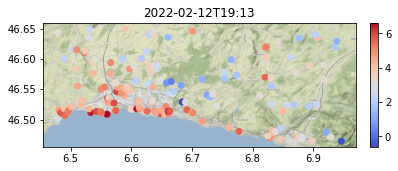
nat.plot_snapshot(gdf)
See the user guide for a more thorough overview of netatmo-geopy.
Acknowledgements
- This package was created with Cookiecutter and the zillionare/cookiecutter-pypackage project template.